
Dorchester-on-Thames
History of the Dorchester Excavation
In 2007 Oxford Archaeology, the University of Oxford and the people of Dorchester-on-Thames came together in the first of what is planned to be many years of joint research and archaeological training.
Dorchester is a key site in British history. It was a prestigious ceremonial centre in the Neolithic and Bronze Age, and is highly unusual in having important Iron Age, Roman and Anglo-Saxon towns in a single place which has suffered remarkably little damage from development.
Investigations at Dorchester will give us a better understanding of three of the key transition points in English history: the move away from tribal society with the growth of urbanisation in the late Iron Age, subsequent incorporation into the Roman Empire, and the rise of early Medieval society from the confused situation arising from the withdrawal of the Roman legions in AD 410.

Since 2007, beginning in the Minchin Recreation Ground, and in the Village Allotments in subsequent years, we have been investigation the Post Roman and Later Roman archaeology of the town. In 2014, we will be going deeper, and perhaps uncovering the earlier Roman origins of such a significant place.
Funding bodies
The Royal Archaeological Institute, Heritage Lottery Fund, The Craven Committee, The Haverfield Bequest, Trust for Oxfordshire's Environment, Oxfordshire Architectural and Historical Society, Oxford Journal of Archaeology
History of the Area
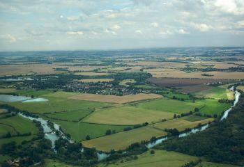
The village of Dorchester-on-Thames lies in a loop of the river Thames at its confluence with the river Thame and is on a peninsula of second gravel terrace above the river floodplains. Today, the village is encircled by gravel quarries which are mainly lakes, giving Dorchester the appearance of sitting on an island. Indeed, over half the peninsula has been quarried away. These quarries were largely active from the 1940s, when one of the most important Neolithic and Bronze Age ceremonial centres in the British Isles was destroyed following only limited excavation of selected sites. Large areas between trenches were not explored, a number of monuments visible on air photographs were not investigated at all and there was very little environmental sampling. Excavations undertaken in advance of further quarrying and the construction of the bypass in 1981 examined the south-east terminal of the cursus and an early Neolithic enclosure and demonstrated the range of small, but important features which probably would have been present over much of the ceremonial monument had it been possible to observe the entire area. Aerial photographs show ring ditches and rectangular enclosures in the area between the cursus and the town and to the west of Bishop’s Court; the ceremonial complex may be more extensive than had been previously thought.
Dyke Hills is a remarkably well-preserved Iron Age oppidum of around 25 hectares to the south of the town, delimited by the Thames to the west and south, the Thame to the east and by impressive ditch and bank earthworks to the north. The dykes are largely intact, although levelled at their east end and riddled with rabbit burrows, the damage from which is a tangible cause of deterioration of the monument. Air photographs have revealed extensive remains of house circles, pits and other settlement evidence within the enclosed area. Traces of later Bronze Age and Iron Age settlement and field systems have also been discovered to the north of the dykes, in the gravel quarries at Bishop’s Court to the west and in the area of the cursus.

Dorchester is one of only two walled Roman towns known in Oxfordshire. The 2nd-century ramparts and later stone defences enclosed an area of c 6 hectares to the west of the river Thame. It was famously excavated by Professor Sheppard Frere in 1962-4 when traces of early Anglo-Saxon settlement were found above and cutting into the Roman levels, and other excavations have revealed similar evidence within the town. Extra-mural Roman settlement is known to lie the north of the town, some of which was destroyed by gravel quarrying and housing developments conducted without archaeological observation. Further settlement and a small group of burials have also been revealed to the west of the defences. Part of an extensive late Roman ‘managed’ cemetery, lying c 700 m north of the town, was excavated at Queenford Farm in 1972 and in 1981, in advance of gravel quarrying and road construction; another apparently similar cemetery on the other side of the Thame near Warborough may have belonged to the town. Both are possibly Christian. The late Roman inhabitants seem to have chosen to bury their dead at some distance from the town, a situation paralleled elsewhere in such places as Verulamium(modern St Albans) raising the possibility that funerary processions played an important role in late Roman burial practices.
Three nationally-important early 5th-century burials have been discovered at Dorchester, a man and a woman found in the Dyke Hills Iron Age ramparts and a woman from a gravel quarry next to the Minchin Recreation Ground. These individuals provide tantalising and in many ways unique evidence of society at the end of the period of Roman rule in Britain. The early 5th-century objects buried with them suggest that they were not merely Roman provincials and that the women at least may have come from north-west Germany. The female burials contained an intriguing combination of Romano-British and Germanic artefacts while the man seems to have been associated with the Roman military. Their wider context is absolutely key, yet remains unknown. Were they interred in a late Roman burial ground(s), or were they so-called 'founder graves' of larger Anglo-Saxon cemeteries? Radiocarbon determinations on five unaccompanied, west - east burials from the Queenford Farm cemetery indicate, remarkably, that the cemetery remained in use, along with the typically late Roman burial rites, through the fifth century and into the sixth, if not later. It would appear, based on this evidence, that several groups, with apparently very different identities, were living in close proximity in and around Dorchester in the 5th century.
In addition to the apparently early Anglo-Saxon settlement within the Roman town, Saxon sunken-featured buildings, a well and inhumation burials were excavated to the west of Bishop’s Court in advance of gravel extraction. Benson and Miles refer to nine Saxon inhumations cut into a prehistoric barrow near to the cursus and removed by gravel extraction.
Sometime near AD 635, Birinus established a bishopric at Dorchester, the first within the kingdom of Wessex. The see was transferred to Leicester in the late 7th century but returned to Dorchester in the 870s where it remained until after the Norman Conquest. In 1071, William I removed the bishopric to Lincoln, leaving the former cathedral site as a minster of secular priests and then, in due course, an Augustinian abbey. The present abbey church contains probable remains of the late Anglo-Saxon cathedral; excavations in 2003 north of the nave found mid-Saxon timber buildings, perhaps associated with the original cathedral foundation. Without the primacy of a bishopric, and with little secular power, Dorchester-on-Thames quietly carried on, leaving Oxford and Wallingford to develop more prominently.
Reserch Design
Dorchester-on-Thames has long been recognised as a key site for the study of British archaeology and history, with nationally important monuments of many periods both within the present village and in its immediate environs. Despite this there has been no archaeological excavation on anything more than a very small scale, and that all in a development led context, for many years, the last excavations of more than minimal size (themselves also in response to proposed development) having been undertaken some 35 years ago in the early 1970s. While understanding of the archaeology of many periods in the Oxford region has advanced very substantially in the last generation (eg Briggs et al. 1986; Blair 1994; Henig and Booth 2000; Booth et al. 2007; Lambrick forthcoming; OA in prep) the well-established potential of Dorchester to contribute to a wide variety of debates has not been matched by increases in the body of data with which to inform these debates, and new questions require new types of evidence to allow them to be addressed meaningfully. With these and other issues in mind, a Dorchester Research Project (see Section 2 below) was set up in 2007 with the aim of focusing attention on a number of the key questions relating to the archaeology of the Dorchester area. It was envisaged that this project would involve a variety of fieldwork approaches as well as re-assessment of earlier published and unpublished data. An overall Research Plan (see Appendix 1 below) was drawn up to provide a clear outline of the questions that might be considered and addressed in the course of future work in the Dorchester area. An initial season of fieldwork in 2007 included excavations in two separate locations (see Section 4 below). These produced very useful results, but were of relatively opportunistic character. In contrast, careful consideration of the Research Plan has underlined the view that a key area for understanding many of the most important questions relating to the development of Dorchester from the late Iron Age into the Saxon period is within the allotments which cover all the south-western quarter of the walled Roman town, an area which is a Scheduled Ancient Monument. This area has been previously examined in part in excavations carried out by Professor Frere in 1962 and 1963 (Frere 1962; 1984), with the area currently of specific interest lying adjacent to the 1963 trenches. Frere’s work indicated the archaeological potential of the area but, by virtue of its relatively small scale, raised as many questions as it provided answers. It is considered that a further relatively modest excavation in this part of Dorchester would shed considerable light on many of the outstanding questions. The present document outlines the background to the Dorchester project and the proposed work, the objectives of such work and methodologies for achieving these objectives.
Download the fuill Research Design (112.3 KiB)
Maps
For a map of the Scheduled Ancient Monument area of the village, click here.
NB: The small irregular enclosed area by the Abbey has been un-scheduled as of early 2009.
Refences
Atkinson R J C, Piggott, C M, and Sandars, N K, 1951 Excavations at Dorchester, Oxon, Oxford: Ashmolean Museum
Benson, D, and Miles, D, 1974 The Upper Thames Valley: An Archaeological Survey of the River Gravels, Oxford: Oxford Archaeology
Blair, J, 1994 Anglo Saxon Oxfordshire Stroud: Sutton
Booth, P, Dodd, A, Robinson, M, and Smith, A, 2007 The Thames through time-the archaeology of the gravel terraces of the Upper and Middle Thames:the early historical period: AD 1-1000, Oxford: Oxford Archaeology
Bradford, J S P, 1942 “An Early Iron Age site at Allen’s Pit, Dorchester”, Oxon 7, 28-42
Bradley, R, 1978 “Rescue Excavation at Dorchester-on-Thames”, Oxon 43, 17-39
Bradley, R, and Chambers, R A, 1988 “A new study of the cursus complex at Dorchester on Thames”, Oxon 7(3), 271-89
Cook, J, and Rowley, T, 1980 Dorchester through the ages, Oxford: University Department for External Studies
Cunningham, C J, and Banks, J W, 1972”Excavations at Dorchester Abbey, Oxon”, Oxon 37, 158-64
Durham, B, and Rowley, T, 1973 “A cemetery site at Queensford Mill, Dorchester” Oxon 37, 32-7
Frere, S S, 1962 “Excavations at Dorchester on Thames, 1962”, Archaeol J 119, 114-49
Frere, S S, 1984 “Excavations at Dorchester on Thames, 1963”, Archaeol J 141, 91-174
Henig, M, and Booth, P, 2000 Roman Oxfordshire, Stroud: Sutton
Hogg, A H A, and Stevens, C E, 1937 “The defences of Roman Dorchester”, Oxon 2, 41-73
Keevil, G, 2003 “Archaeological investigations in 2001 at the Abbey Church of St Peter and St Paul, Dorchester-on-Thames, Oxfordshire”, Oxon 68, 313-362
Kirk, J R, and Leeds, E T, 1954 “Three early Saxon graves from Dorchester, Oxon”, Oxon 17-18, 63-76
Loveday, R, 1999 “Dorchester on Thames– ritual complex or ritual landscape?”, in (eds A Barclay and J Harding) Pathways and ceremonies : the cursus monuments of Britain and Ireland, Oxford: Oxbow, 49-66
Munby, J, and Rodwell, K, 1974 “Dorchester”, in (ed K Rodwell) Historic towns in Oxfordshire, Oxford: Oxford Archaeological Unit, 101-08
Rowley, R T, 1974 “Early Saxon settlement in Dorchester”, in (ed R T Rowley) Anglo-Saxon settlement and landscape, Oxford: BAR, 42-50
Rowley, T, and Brown, L, 1981 “Excavations at Beech House Hotel, Dorchester-on-Thames 1972”, Oxon 46, 1-55
Stevens, C E, and Keeney, G S, 1935 “Ramparts of Dorchester”, Antiquity 9, 217-9
Tiller, K, 2005 Dorchester abbey: church and people 635-2005, Witney: Stonesfield Press
Whittle, A, Atkinson, R J C, Chambers, R, and Thomas, N, 1992 “Excavations in the Neolithic and Bronze Age complex at Dorchester-on-Thames, Oxfordshire, 1947-1952 and 1981”, Proc Prehist Soc 58, 143-201
Background
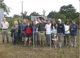
The pilot excavation undertaken in July 2007 as a joint project between the University of Oxford and Oxford Archaeology was a great success. Over a period of three weeks thirteen local volunteers joined the Oxford postgraduate students to be taught the techniques of professional archaeology by OA staff. The excavation focused on two sites, the Minchin Recreation Ground and a private garden in Haven Close. Both sites produced some very interesting results.
Historic mapping suggests that the recreation ground was used as farmland from at least the 16th century until it was donated to the village as a recreation ground in the 19th century by Mr Minchin. Aerial photographs taken in 2001 as observed on Google Maps show a series of intriguing cropmarks, and subsequent geophysical survey undertaken as part of the project, confirmed the likely survival of potentially significant archaeological remains.
The Parish Council and the cricket club kindly agreed that an excavation area could be opened over a series of cropmarks in the south east corner of the recreation ground. From Google Earth these appeared to show part of a curvilinear feature, characteristic of a Bronze Age ring ditch, (a ploughed-out burial mound), and a square enclosure with a large pit-like feature lying just inside its western boundary.
Excavation
Excavation confirmed the presence of the ring ditch, which had previously been unknown. This would suggest that the Bronze Age cemetery associated with the Dorchester cursus and the Big Rings henge extended much further south than had been thought. Assuming that the ring ditch was symmetrical, it would have had an internal diameter of c 30m. Consequently, the projected location of the central burial was to the south of the excavation site (under the basketball court!).
No evidence for Iron Age activity was recovered, which probably reflects the focus of settlement in the late Bronze Age and Iron Age at Castle Hill and Dyke Hills. The vast majority of the artefactual material recovered from the site was from the 4th century AD, (late Roman period), and was deposited within the western, southern, and eastern boundary ditches of the rectangular enclosure which cut across the Bronze Age ditch, and also in the top of the pit-like feature, which turned out to be a Roman waterhole or well. The numerous and large unworn pot fragments, suggest that the finds have come from the immediate vicinity of the site, and may imply a high-status building near by. Significant quantities of copper and iron slag also suggested metalworking in the area.
Trench 2
Haven Close - our second trench in the back garden of Dave Wilkinson, a Senior Project Manager at OA, produced some beautiful samian pottery imported from the south of France in the early Roman period. The house and those around it stand on a large platform, just south of the Roman town. Was this a Roman feature? And was there a cemetery in this area, as the location might suggest? Within a few days we were cleaning up the skeleton of an infant, found near the base of the topsoil. The skeleton has now been radiocarbon dated to somewhere between AD 240 and AD 390, but the lack of a clear stratigraphic context meant we had to treat it as suspicious at the time. The local Scene of Crime Officer from Thames Valley Police was both helpful and pragmatic, allowing OA human bone specialist Louise Loe to do the excavating and recording. The skeleton and related samples then stayed sealed in an evidence bag until the C14 date had been obtained. This must have been a shallow burial, pushed in just below what was then the turf-line, and perhaps not within a formal cemetery. No other burials were found.
More Roman features were found once the topsoil had been cleared down to the top of an orange-brown subsoil. A deep ditch, more than a metre wide, crossed the trench running roughly north to south. And then there was Roman pottery - bucket-loads of it. We have yet to analyse this in detail, but it is already clear that unlike the Recreation Ground site, where the pottery was largely late Roman, we have mainly first century pottery, some of it dating to not long after the invasion. A highlight was a stamped Samian ware base, reading OFNIGR. The most likely meaning of this is OFFICINA NIGRI, meaning the pot came from the work shop of the potter, Niger, in La Graufesenque, in southern Gaul (France). He operated from AD 50 to AD 80. By this time we had also started to find prehistoric worked flints in the top of subsoil. These ranged from Mesolithic microliths to rough blades, flakes and cores from the Neolithic or Bronze Age.
The ditch might have defined the back of a cemetery which lay further west, towards the known line of a Roman road. We have heard on the local grapevine how human bones were found during building in the 1950s. For the earlier evidence, understanding the flints is easier now that we believe the subsoil, which overlies river sands and gravel, was at one time a topsoil covered by either grassland or woodland. It seems to have stayed that way during the Late Iron Age period when nearby Dyke Hills was occupied, until the establishment of Roman Dorchester. And what about the raised platform that had first made us curious? There was no evidence that this was Roman - it seems more likely that it was naturally a slightly higher area than the surrounding river floodplain. As such it would make a favoured place for prehistoric hunters and fishers - hence the flints.
Visitors
The project was delighted to welcome two visits from Dorchester Primary School, and 60 visiting undergraduates who were excavating at Frilford during the same period. We also had daily visitors whom were either walking their dogs, or taking their children to the play area, which made for a very sociable atmosphere. Thankfully, our presence did not impact too greatly upon the Cricket Club, to whom we are very grateful for the use of the pavilion.
Evening Lectures
Over the three weeks of the dig we gave a series of six evening lectures on the archaeological history of Dorchester from the Neolithic to the medieval period. These were very well attended, and gave people the opportunity to ask as many questions as they wished.
Results of the 2008 Excavations
The site lies in the south-western part of the Roman town, an area last examined in 1963 by Professor Sheppard Frere. Based on his work, key questions to be examined relate to the origins and early development of the Roman town, in particular the question of the date and character of a possible fort, and the transition from the late Roman to the Anglo-Saxon period. So far, excavation has concentrated on examining spreads of rubble, probably derived from Roman buildings, which may have been used to support Anglo-Saxon timber structures. At the east end of the site part of the main north-south road which bisected the Roman town has also been found.
Large quantities of pottery and animal bones have been recovered. The pottery is mostly of late Roman date but includes some Anglo-Saxon sherds, and Roman building material (brick and tile) is also common. Other objects found include Roman coins, an intaglio from a signet ring, part of a small bronze figurine and personal items such as hairpins and tweezers. Saxon finds include objects associated with spinning and weaving and part of a tool, perhaps a rake, of deer antler.
Excavations will continue on this site in 2009 to enable more of its story to be revealed.
Read about the geophysical survey campaign of 2008.
Download the summary of 2008 results (16.4 KiB)
Geophysical Survey 2008
|
|
 |

New discoveries were made by the Oxford University Department of Continuing Education (OUDCE) training survey at Dorchester-on-Thames in 2008. An exciting and productive week long training survey course was conducted by Oxford Archaeology with a team of MSc students from the between 14th and 20th June, directed by Dr. David Griffiths and Dr. Gill Hey.
With the Dorchester Training Excavation due to start on 29th June on the village allotments, it was agreed that activities would aim to compliment the established research objectives of the excavations. These are to examine the major periods of transition in the village's history (for which Dorchester has unparalleled evidence), creating a picture of close to five thousand years of change and shedding light on the development of medieval and modern England.
To the north of the village magnetometer survey found the end of the Neolithic cursus, most of which was comprehensively destroyed by gravel extraction and the construction of the bypass from the 1940s to 1980s, and an unrecorded ring ditch. Behind Dorchester Abbey in the Hurst water meadows the team (below left) found hitherto unknown medieval fish ponds, which were no doubt part of the extensive Abbey complex before dissolution. The development of the medieval Abbey Guest House was recorded by the students (above). OA's team of instructors were: Leo Heatley, Anne Kilgour, Gary Jones and Jane Phimester.
Results of the 2009 Excavation
The principal objective for 2009 excavation was to try to identify, and date, the faint traces of probable middle Saxon buildings and clarify their relationship to the Late Roman and any earlier Saxon features on the site.Such buildings were difficult to confirm, but the secondary objective of removing the dark earth layer was achieved.
At the eastern end of the trench, deposits overlying the Roman road were removed. Gravel layers at the western margin of the road were continuous with its surfaces. Both road and adjacent surfaces were cut by a number ofpits, and the road itself was also cut by a N-S row of postholes, suggesting astructure had been placed upon the metalled surface. The pits identified in 2009 were not excavated at the time, but a Late or Post-Roman date seemedlikely. Some pits were related to the sequence of dark earth deposits that originally covered most of the site, particularly in the central area, where successive spreads of stone within them indicate that they had accumulated over an extended period. The dark earths seem to have overlain and been cut by pits, but as the soils were virtually identical, some pits were only clearly identified when indicated by a marked concentration of animal bone and stone.

Removal of the dark earths in the NW part of the site, where they were thinner, revealed mixed gravel deposits. One well defined sub-rectangular patch of gravel may have formed the floor of a building measuring c 5 x2.5m and aligned N-S. Apart from the ephemeral outlines showing in the adjacent post-rain photograph, no clearly related structural features werei dentified, so the interpretation is uncertain.

An E-W aligned ditch lay at the southern margin of this gravel patch and extended through the centre of the site, curving then curving south-eastwards to approach the line of the Roman road. This ditch was unexcavated in 2009, but was assumed to be post-Roman.
Results of the 2010 Excavation
July 2010 saw the third consecutive season of excavation by the Dorchester Project team in the allotments which overlie the south-west quarter of the Roman town. Work continued in the same 30 x 20 m area as in previous years, with the main north-south Roman road through the town at its eastern margin. It now seems likely that in the late Roman period most of this was an open area, at least partly surfaced with gravel, and perhaps serving as a market place or other public open space. Fragmentary remains of a building c 5.5 m wide, probably of timber construction on a rubble foundation and fronted by a gravel surface, have been found at the west edge of the site some 25 m from the road line. The date of the building is not yet known, but it must have been out of use by the time it was cut by a late Roman ditch, which lay alongside the Roman road in the south-east corner of the site and then curved away from it to the north-west, eventually running beyond the edge of the excavated area in a westerly direction. By the time that this ditch was dug, probably after AD 350 at the earliest, a considerable number of pits and shallow hollows had been dug in the area between the road and the building to the west. Some of these features were used for rubbish disposal, but whether or not this was their original function is uncertain. Although certainly late Roman in origin its uppermost fill produced early Saxon pottery.
Just to the north, at the western edge of the Roman road, lay a small early Saxon sunken-featured building or Grubenhaus. This is a characteristic building type of the period, represented here by a shallow hollow c 3.2 m x 2.4 m, with a hole for an upright post at each end. The posts are usually reconstructed as supporting the ridge-pole of a simple roof structure with a basic tent-like appearance. There is no indication of any particular use of the sunken area, but most of these buildings are thought to have had wooden floors raised above the sunken area, which may have served for storage. Finds from the structure were mostly of later Roman date, but include a small but significant group of early Saxon pottery, although close dating of the latter is very difficult. Buildings of this type are sometimes found in Roman towns, but are not common in such contexts. The present example is significant because it mirrors one of broadly similar type excavated by Professor Frere in 1962 roughly 50 m south of the current site and in an exactly corresponding roadside location.

Restoration work in the Iron Age ramparts of the Dyke Hills enclosre also brought new information to light, with the discovery of human remains that were radiocarbon dated to approximately AD370 (cal) and which were accompanied by an exquisite chip-carved Late Roman belt set and and iron axe. These items were most kindly donated to the Ashmolean museum by landowner Miss A Bowditch and are currently on display in the England gallery.

DORCHESTER ALLOTMENTS EXCAVATION 2012: BRIEF SUMMARY
Excavation by the Dorchester Project team in the allotments which overlie the south-west quarter of the Roman town continued throughout July after a break in 2011. This was in the same 30 x 20 m area as in previous years, with the main north-south Roman road through the town at its eastern margin. This year’s work concentrated on a number of Roman ditches and related deposits. The Roman road was also partly sectioned, revealing a number of superimposed surfaces. It is possible that there was a roadside ditch on the west side of the road from early in the period, although if so this was sealed by later layers. A fragment of mortar floor suggests that there may also have been at least one roadside building in the same general area. Further west, a building at the west end of the site, some 25 m from the road line, first seen in 2010, is now known to have been larger than originally thought – its east side was at least c 10 m long. This building probably lay within an enclosure with on its eastern side a palisade set in trenches which extended north and south beyond the edges of the site. A gap in the palisade trenches aligns with the mid point of the east wall of the building, suggesting that there was an entrance at that point. The date of these features is not yet known, but the palisade trench was later recut as a boundary ditch, retaining the entrance opening.
Later ditches transformed the use of the area. More work was done on a ditch, already examined in part, which lay alongside the Roman road in the south-east corner of the site and then curved away from it to the north-west, eventually running beyond the edge of the excavated area in a westerly direction through the opening in the north-south palisaded/ditched boundary and cutting the associated building. This curvilinear ditch, perhaps of later 4th century date, had a small entrance in its northern side, between the road and the now disused enclosure/building complex to the west. What it itself enclosed is uncertain, although it must have been more than just the extensive midden deposits located in the southern part of the site, but any potential high status settlement components would have lain south of the excavated area. Two more east-west ditches were found running close to the north edge of the site. These were deeper and more steep-sided than the curvilinear ditch, but were of roughly similar late Roman date. Their function is uncertain, but if they too were enclosure ditches they would have related to an area north of the site.
The curvilinear ditch and the adjacent palisade ditch terminal to the south were cut by a pair of pits. One of these was perhaps very late Roman in date, and contained part of a decorated bone comb along with other finds, while the second pit produced early Anglo-Saxon pottery. Large quantities of finds were recovered, as usual. Most notable amongst these were a fragment from a late Roman pottery vessel decorated with figures of deities in niches, and a coin of Edward the Elder (AD 899-924). The latter, from the top of the fill of the curvilinear ditch, does not seem to relate to excavated features within the site, but is a useful (and rare) indicator of the continued importance of Dorchester in the mid Saxon period
DORCHESTER ALLOTMENTS EXCAVATION 2013: BRIEF SUMMARY

The training excavation run by the Dorchester Project team which commenced in 2008 in the allotments overlying the south-west quarter of the Roman town continued throughout July 2013. This was in the same 30 x 20m area as in previous years, with the main north-south Roman road through the town at its eastern margin. A pending change in allotment allocations, with the likelihood that part of the western end of the site will not be available for examination in 2014, meant that excavation was concentrated solely in the western half of the area with a view to elucidating as much of the overall site sequence as possible within this area. This involved the removal, in parts of the site, of substantial depths of deposit, up to 0.70m in places.
The natural ‘brickearth’ subsoil was revealed at a number of locations within the western part of the site. It was shown to have been cut by a variety of features, including probable pits and a number of gullies. A roughly east-west aligned pit (or possible ditch terminal) (3737) at the west end of the site contained a substantial finds assemblage including animal bone (dominated by sheep and pig) and, amongst the pottery, a large part of a fine white ware butt beaker repaired in antiquity. Further east a length of NNE-SSW aligned ditch or elongated pit (3724) had unknown relationships with two narrow east-west slots – although closely adjacent, none of these features appeared to intercut. Only short lengths of the east-west slots (3723 and 3733) were observed. South of these, however, a further, wider east-west gully (3746) appears to have been cut by feature 3724; again only a short length of 3746 was observed. A little further to the south again was another possible linear feature (3655), this time aligned roughly NW-SE, which contained a pottery assemblage dominated by local coarse wares and unlikely to date after c AD 70 at the latest. Finds from the other early features included a Nauheim derivative brooch and a strip brooch from gully 3733.
Towards the north-west corner of the site another possible early feature was a probable well, only partly examined. The upper parts of this feature were not clearly understood as they had probably been affected by sinkage before being largely removed by late Roman ditches. The main upper fill of the feature contained pottery of mid-late 1st century date.
These earliest features were sealed (or, in the case of the putative well, probably sealed) beneath a substantial homogeneous deposit (3541/3574 etc) of brown clayey loam which was up to c 0.50m deep at the western margin of the site and extended at least 15m eastwards from that point; its eastern limit is not yet known. The finds from this layer have yet to be examined in detail so its date is unclear, as, equally, is its interpretation. One possibility is that it represents a dump or levelling up deposit, but the apparent homogeneity of the soil rather argues against this. Alternatively the layer may have formed as a gradual accumulation from the later 1st century onwards, suggesting relatively low-level use of the area at this time. If so, this might have interesting implications for understanding of the nature and intensity of activity in what was, after all, a fairly central location within the town. A further possibility, however, is that the layer formed as garden soil behind buildings fronting onto the main north-south road through the town, although evidence for such buildings is still elusive.
At the western end of the site, excavation of parts of a building already partly examined in previous seasons was completed. This structure was set upon the major build-up layer, probably not before the later 2nd century and possibly even later. Its construction was unusual; the superstructure, which must have been timber framed, was set mostly on irregular limestone boulders placed in a very poorly-defined construction trench cut into the build-up layer. The structure may have been initially in two parts – a northern unit measuring at least 8m north-south, and a smaller element about 2m north-south immediately to the south and with its ‘frontage’ on the same alignment (the exposed east-west ‘depth’ of both rooms being only 2m). The smaller unit contained a poorly-preserved hearth and was associated with substantial dumps of oyster shell immediately outside to the south, characteristics which suggest a possible interpretation as a kitchen structure, though some of the oyster deposits apparently predated the structure. A probable well (not yet completely excavated) immediately east of this structure was probably contemporary with it and would have been entirely consistent with this interpretation. In a subsequent structural phase the two rooms seem to have been linked to form a single building, the foundations being remodeled at this point. Deposits apparently contemporary with the use of the northern room produced coins of early-mid 4th century date and suggest continued use at this time. As previously suggested, the building seems to have been placed within a palisaded enclosure with an east-facing entrance roughly 3.5m wide broadly in line with the centre of the building facade, although the alignment of the southern part of the palisade trench/ditch was not very regular in relation to either to the building or the western edge of the road, from which the front of the building was set back about 24m.
Immediately east and partly in front of the enclosure was a small enigmatic feature, consisting of a sub-rectangular limestone and flint rubble spread with maximum dimensions of c 3m east-west and 2.5m north-south, partly set on a layer of large amphora sherds. The rubble was most clearly defined on its southern side, albeit with a slight but marked offset in this otherwise straight alignment, and had traces of northward extensions at its west and east ends, within which was a deposit of fragmented limestone roofing material. In addition, a single row of stones formed a small horn-like extension running south-westwards from the south-west corner of the rubble spread. A substantial part of a small grey ware beaker of later 2nd century type was associated with the feature and might possibly be relevant to its interpretation. The latter is unclear, however; while clearly significant, it is not certain if the feature carried a structure or, if so, what form this might have taken. The association with the entrance into the enclosure seems to have been deliberate, and stratigraphic associations indicate that the feature could have been contemporary with the primary phase of the building to the west.
The secondary structural phase of the western building was associated with the deposition of a substantial gravel surface. This was laid up to the frontage of the building but also extended out of the enclosure and was widespread across the northern part of the site. The gravel was laid over the rubble spread feature described above, sealing it, but it is notable that the southern edge of the gravel was laid only just south of the rubble base structure and never extended into the southern part of the excavated area; here there appears to have been relatively little complex stratigraphy until the commencement of deposition of the sequence of late Roman and later midden deposits examined in previous seasons.
North of the stone based feature the extensive gravel deposit overlay postholes and other possible structural features which may indicate the presence of a further structure in this area between the palisaded enclosure and the north-south Roman road, but further work is needed to clarify the nature of these features. Further deposits in the same area produced a number of interesting small finds including gaming counters and several brooches.
A little further work was carried out on remaining parts of the late Roman ditches in the western half of the site. This confirmed that the upper parts of the probable 2nd century palisade trench had been recut in the later Roman period and had probably not completely infilled before the end of the period. As previously noted, the northern arm of the palisade trench was cut by two close set east-west aligned ditches with steep sided V-shaped profiles, the more northerly of which is only partly within the excavated area. It seems likely that these form a boundary (perhaps an enclosure) defining activity to the north. It is not clear if these ditches respected or removed the position of the north-east corner of the main building at the west end of the site. The building was certainly cut by another ditch, largely excavated in previous seasons, which ran parallel to the east-west ditches in the western half of the site before curving south-eastwards towards the line of the Roman road. As discussed previously, this ditch presumably defined an enclosure, part of which lay within the southern and south-western parts of the site.
DORCHESTER EXCAVATION SEASON 2014

We have had a fantastic season in 2013, and the weather was better than we could have hoped for. You can see a 360-degree panorama of the excavation produced by the Institute’s photographer Ian Cartwright here. You can also read about us on the past pages of our Excavation blog. This upcoming season the project will continue in the Village Allotments, led by Paul Booth. We will be pursuing the story of earlier phases of Roman life within the town walls and trying to put the late 1st/2nd century features and material from last season into context by looking at the eastern side of the trench in more detail. We will explore the construction of the Roman road, try to identify roadside activities, and plumb the depths of the probable early-mid Roman well we discovered last season.
The village of Dorchester-on-Thames lies in a loop of the river Thames at its confluence with the river Thame and is on a peninsula of second gravel terrace above the river floodplains. Today, the village is encircled by gravel quarries which are mainly lakes, giving Dorchester the appearance of sitting on an island. Indeed, over half the peninsula has been quarried away. These quarries were largely active from the 1940s, when one of the most important Neolithic and Bronze Age ceremonial centres in the British Isles was destroyed following only limited excavation of selected sites. Large areas between trenches were not explored, a number of monuments visible on air photographs were not investigated at all and there was very little environmental sampling. Excavations undertaken in advance of further quarrying and the construction of the bypass in 1981 examined the south-east terminal of the cursus and an early Neolithic enclosure and demonstrated the range of small, but important features which probably would have been present over much of the ceremonial monument had it been possible to observe the entire area. Aerial photographs show ring ditches and rectangular enclosures in the area between the cursus and the town and to the west of Bishop’s Court; the ceremonial complex may be more extensive than had been previously thought.