
Ebb & Flow

River Avon at Ibsley

The centrality of rivers in Britain comes to the fore in the Bronze and Early Iron Ages (c. 2500–400 BC) – a period of unprecedented human/object mobility. Fields, settlements, and burials accrued along river valleys, riverine human/object offerings burgeoned, and travel along rivers increased. However, our understandings of rivers are fragmented: archaeologists have focused on the largest and hence potentially atypical examples, and they have often treated rivers as passive backdrops for human action. Ebb & Flow will put rivers first – offering a novel, in-depth look at human activities along/near/in/on four diverse river systems and illuminating how rivers actively transform the world.
Ebb & Flow will challenge current understandings and address outstanding questions about human-river interaction in later prehistoric Britain by exploring rivers at multiple scales using a diverse suite of data, drawing on archaeology and biomolecular science, anthropology and earth science.
The centrality of rivers in Britain comes to the fore in the Bronze and Early Iron Ages (c. 2500–400 BC) – a period of unprecedented human/object mobility. Fields, settlements, and burials accrued along river valleys, riverine human/object offerings burgeoned, and travel along rivers increased. However, our understandings of rivers are fragmented: archaeologists have focused on the largest and hence potentially atypical examples, and they have often treated rivers as passive backdrops for human action. Ebb & Flow will put rivers first – offering a novel, in-depth look at human activities along/near/in/on four diverse river systems and illuminating how rivers actively transform the world.

Ebb & Flow case study areas
Ebb & Flow will challenge current understandings and address outstanding questions about human-river interaction in later prehistoric Britain by exploring rivers at multiple scales using a diverse suite of data, drawing on archaeology and biomolecular science, anthropology and earth science.

Ebb & Flow is currently funded by a Leverhulme Trust Research Project Grant
Festival of Archaeology
On 16 July 2020, the Ebb & Flow team took part in the Festival of Archaeology by giving a Twitter paper at the Museum of Liverpool's Twitter conference: Climate, Environment and Archaeology. You can check out the conference here #ArchMoL20, and read our paper in Co-I Fraser Sturt's feed @FSturt!

Plant sampling on the Avon
In the project's first fieldwork, modern plant samples were collected to help create a strontium isotope baseline map, an ‘isoscape', against which values for humans will be compared. A national strontium isoscape is already available, but its spatial resolution is coarse. The results will not only help frame the interpretation of humans in the study, but will contribute to refining the regional and national isoscape.
Image

Hengistbury Head, start of the journey. Site of a Late Iron Age trading emporium focussed on connections with the Continent, and facilitated by access to the hinterland supplied by the Rivers Stour and Avon. Strontium isotope values here may be heavily influence by sea spray, which certainly could be felt on the day. Plant samples are georeferenced using a handheld Garmin GPSMap 62.
Image
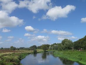
River Avon at Ibsley.
Image

Access to parts of the Avon is strictly controlled today. To what extent was this also the case in late prehistory?
Image

The stability of the Avon's banks at Fordingbridge is well-maintained by vegetation. A large Bronze Age cremation cemetery was found nearby.
Image

Sampling a small tree in a very different heathland environment near Cripplestyle, just a few kilometres west of the Avon.
Image

Sampling a small tree on the chalk downlands near Cranborne west of the Avon. The strontium isotope signature of plants growing on the chalk tends to be very consistent, centring on ca. 0.7080, but it is always worth getting additional confirmation.
Image

The chalk downlands present a very different landscape to that of the Avon Valley, yet the two are within only a few kilometres of one another. Prior to the late nineteenth century, the valley's water meadows and the chalklands were closely interconnected in an integrated farming system.
Image

Back in the Avon Valley at Churchill Park, Salisbury, the northernmost point of the trip, some 40 km from the starting point.
Image

Taking advantage of branches brought down by Storm Ellen, 20 August, in Churchill Park, Salisbury.
Image

Image

Sampling along the eastern side of the Avon Valley near the boundary between the Chalk and the London Clay. The British Geological Survey's iGeology and mySoil apps were invaluable aids in guiding the sampling strategy.
Image

The floodplain was heavily managed to provide valuable grasslands for grazing and hay cropping from the seventeenth century. How it was used in earlier periods is less clear, particularly for prehistory. Access to the river may have been far more difficult because of dense vegetation and reed beds.
Image

The view over the Avon Valley from Godshill, with Chalk downlands to the west, and very different geological formations to the east, consisting of clay, silt, and sand deposits. This difference is captured by strontium isotope values for plants growing here, and will aid in the construction of a more detailed strontium isoscape for the Avon that will contribute to a better understanding of how the landscape was used in prehistory. In total 42 samples were obtained from 20 locations.
Photographs by Joanna Ostapkowicz. Our furry four-footed helpers are Obi and Kenta, honorary members of the advisory group (very much on probation).

We were awarded a Public Engagement with Research Seed Fund grant from the University of Oxford. In our unsettled time of pandemic and social distancing, urban and semi-urban communities are connecting with nature in new and increased ways, including through parks and common lands. A recent government poll showed that UK residents were spending more time outdoors than normal. We want to create something positive in this stressful moment by bringing small bursts of culture and knowledge directly to people at specific sites in the landscape, using the platform of a noticeboard. This collaborative project combines the efforts of the School of Archaeology's Artist-in-Residence, Miranda Creswell, and the Ebb & Flow team.
This interdisciplinary project will bring unexpected bursts of culture to people both on location and through online engagement and expand their sense of time depth. The Ripple Effect will take archaeological places near rivers and turn them into outdoor culture hubs, where original artworks and new research will be installed on community noticeboards. It will create a series of artworks, learning materials, and short films all accessible online, to reach people both indoors and out and enhance their experience of riverine landscapes.
